The history of water system change in the Pearl River Delta is the development track of human settlements in urban and rural areas centered on Guangzhou and Foshan. The ancient post roads in South Guangdong accounted for a large proportion of water and post. Before motor vehicles appeared, waterways could be regarded as a direct and fast transportation channel by using large and small rivers in the river system of South Guangdong. At present, all cities are remediation of black and smelly water bodies and river environment, among which multi-river connection is a new change of water system pattern in the future. It is necessary to plan in advance how to convert the geographical advantage of the developed water system of Guangdong into the "New South Guangdong Water Yi" of Guangdong when the river flow becomes clear and adapt to the changes of the future life style. Since the 1960s, France, Belgium, Germany, Holland and other countries in Europe have made use of the historical canals and the natural rivers to form a network, changed the traditional transportation mode and upgraded it to the popular recreational water upstream, which provides a kind of reference paradigm for the active utilization of "South Guangdong Shui Yie".
1.Canals and Parades in Amsterdam
Around 1550 Antwerp became an important centre for map printing, and a large number of independent maps and atlas were published. Secularized commercial impulses promoted the accuracy of map measurements. The growth of the Dutch Republic in the 16th century allowed Amsterdam to surpass Antwerp and Utrecht during this period. Amsterdam, in the Netherlands, grew from a small village in the 12th century and grew as a result of trade. "In 1275, Amsterdam was granted self-government by the Dutch count, and its commerce grew steadily thereafter. In 1306, another constitutional law recognizing and increasing rights in Amsterdam was ratified, and in the latter part of the century, the city square and the first town hall were built." [1]
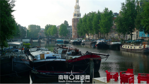
Amsterdam has more than 100 kilometers of canals, 90 islands and more than 1,500 Bridges of various kinds, with historic buildings built in the 16th and 17th centuries on both sides. It was listed as a World Heritage Site in 2010. When Antwerp declined and the secular city of Amsterdam rose, a Map called the Waterschap Map was widely used between 1572 and 1650, which was used by companies or institutions with water management qualifications to construct reclamation and sewerage systems. Amsterdam is a typical example of the secular public power that dominates urban development in the Low Countries. In the 13th century it was just a small village on the Amstet River. From the preserved historical maps, we can see that in the late 16th century and early 17th century, Amsterdam implemented the plan of canal port. Through the canal, the marsh was drained and the land was filled. Through the land sale, funds were obtained for the construction of the city, forming the canal zone and expanding the size of the city.
"Survey" originated from the registration of real estate after the measurement of land. In 1300-1330, the Dutch Earl set up the position of "surveyor". Geographers, architects, monks and military engineers participated in the survey and the drawing of maps, but they were not officially recognized surveyors. The earliest recorded document of surveying was in 1282, which belonged to the parish of Utrecht, and the maps were used as evidence in court cases. In the Low Countries, where land is being bought and sold, the need for accurate maps is increasing. [2] Amsterdam is a city that grows rapidly through land reclamation because of its dominant secular ruling power. Land reclamation requires accurate maps, and market demand is an important driving force for map making.
The drawings for sale in order to partition the reclaimed land are the result of reasonable zoning of the land, which ensures the standardization of the public road. From the perspective of economic benefits, the subdivision of the strip of land increases the income of the land, which is also the inducement for the formation of the unique style of the townhouse in Amsterdam today. Amsterdam's Singel Canal townhouses form a distinctive view of the city. The Singel Canal also served as a military defensive moat from 1480 until 1585, and the Muntplein is also located on the river.
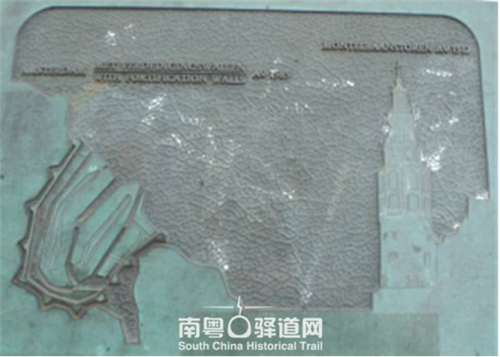
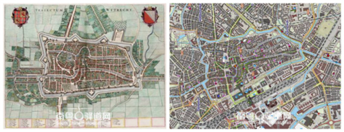
An aerial view of the city of Amsterdam made in 1544 shows the Singer Canal on the right, and you can see that the city has just expanded into this area. The cartographer was Cornelis Anthonisz (1505-1553), an Amsterdam-born painter and cartographer of the Golden Age, who produced it in 1536 and published it in 1544. C. Antoninz was a famous painter, printmaker, and cartographer of Amsterdam in the 16th century. He produced several artistically accurate, realistic aerial views of the city, and in 1538 his map was presented as a gift to the Holy Roman Emperor. A 1544 map by C. Antoninzi shows a complete system of walls, with the river Amstel flowing into the city. The coinage along the important Singel waterway in the city is the defensive tower of the city wall built in 1480, where the gates are located.
The 1662 map of Amsterdam by the architect Daniel Stalpaert (1615-1676) is more technical, showing the rigorous academic flavour of urban planning. The architect was involved in the construction of the Amsterdam City Hall and the expansion of the city, and the building he designed became an important historical building that remains to this day.
C. Antonitz and Daniel's maps, the 1544 map is kind of a status map, and the 1662 map is kind of a planning map. Through a network of plans, the canals are connected, and the land is cut and sold. The size of the city has been quadrupled, and both spatial capacity and finance have benefited. Unlike Crown and Lordship, land reclamation was the prerogatives of city halls, which increased the flexibility of commercial operations.
The concentric circular canal city of Amsterdam is related to the theory of Simon Stevin (1548-1620), a Dutchman who was an important urban theorist of this period. He was also a mathematician and engineer who had unique views on port cities. He emphasized the relationship between the canal and the port. The canal runs through the city in parallel to the suburbs, and the urban model it advocates provides flexibility for development. His theory influenced the planning of Antwerp and Amsterdam. [3]
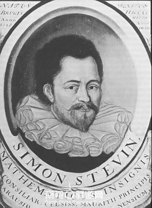
In the 17th century Amsterdam was often compared in two urban models, the Ideal Cities of Daniel Speckle (1532-1589) of Alsace, The other is Simon Stevin of Bruges (1548-1620) with his gridded reathering pattern. He believes that the outer dimension of the city is 2.8 kilometers long and 2 kilometers wide, which is reasonable and comfortable. Amsterdam adopted Shimon Stewin's urban scale and model 70 years later. [4] Himon Stewyn mentioned that he was inspired by the floating city of Amsterdam at that time when he was thinking about abstract urban layout, and his theory was applied in reverse when Amsterdam planned to expand its urban area.
The Seventeenth Century Canal Ring Area of Amsterdam inside the "Seventeenth Century Canal Area of Amsterdam inside the" Singelgracht, a World Heritage site, says: "These new urban Spaces can be developed in a unified way to create commercial housing and a large number of monumental buildings. Amsterdam's urban sprawl was the largest and most balanced development of its kind during this historical period. This historic district is also an example of large-scale urban planning that continues to be used around the world until the 19th century." A 1607 canal construction plan quadrupled the size of the city, with each canal serving as a boundary for urban development.
The population of the city was 30,000 in 1585, 50,000 in 1600, and 200,000 in 1670. The outer walls have always taken the form of redoubts. [5]
Bastioned walls, built in 1593, were allocated along the first ring of the canal, known as the Heerengracht, to extend the city in parallel with the construction of a second and a third canal, which created land with a clear purpose. The cost of rebuilding the ramparts of the redoubts was commercial, financed by the private sector, and the new land was sold to the public. In 1607, the planned city land was quadrupled in size.
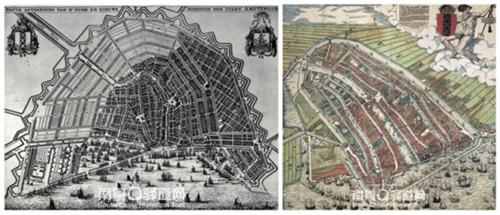
From Blau's map of Amsterdam in 1649 and Frederik de Wit's map of Amsterdam in 1688, we can see the gradual outward expansion of the city wall. In Blau's map, the function of the land was not clear in the northwest, and the construction of the city had not yet extended into the northeastern part of the city wall. It is judged that there is no construction in space. But 30 years later Fraudlik's map in 1688 showed that the urban land was essentially functioically used.
In the late Middle Ages, the secularized urban form of Europe was obvious, and canals, ports and their commercial migration became the driving force of urban development. From the 17th century to the 18th century, Europe formed several cities that were dynamic and rapidly expanding and filled with talented people. The rise of this series of cities was closely related to maritime trade and the development of European colonies in other parts of the world. The canal extends the port quay shoreline, obtains the enlarged land space of the fill, reflects the public interest urban planning.
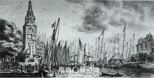
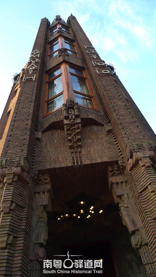
COINS or called monte towers (Munttorn) is Amsterdam the history of the landmark buildings, a tower with style design style, the walls of Amsterdam is hundreds of years the process of dismantling and the expansion of city scale, the old history retained gates are now in the city, COINS or monte towers is the gate of the original 1480. A fire in 1618 destroyed the East Tower, leaving only the West Tower. Rembrandt made a special note of the view of the West Tower after the fire destroyed it. It was decorated in a Renaissance style in 1620 by Hendrik de Kaiser, who designed the tower with an open roof and installed four clocks on the four sides. In 1668 a bronze bell assembly was installed on the top of the tower. In the 17th century, because of the security features of the building, the tower was used as a storage building for silver and gold coins, later known as the Mint Tower. Another form of city emblem is embedded in the annex, with the crew of a galleon carrying the flag of the City of Amsterdam's heraldic flag and the heraldic shield of the Kingdom of the Netherlands. Now the Mint Tower has become the downtown area, and the Mint Square has become a busy space for public events in the city, the main Mint Square (Muntplein) of Amsterdam.

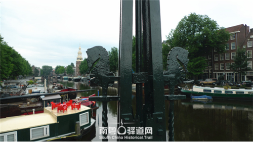
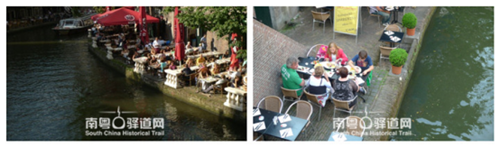
There are many Bridges across the canal, and the canal landscape is the most historically valuable resource of Amsterdam city tourism. The various Bridges on the canal are important nodes.
The evolution of Amsterdam's urban form is different from the traditional medieval cities in Europe. It can be said that it is a process of secularized urbanization. The development of the city lays more emphasis on the trade and navigation functions of the port, and land reclamation increases the urban capacity. Amsterdam created a unique pattern of urban traffic and urban structure. The concentric ring canal, land traffic and water traffic were planned and constructed at the same time, and locks and Bridges played an important role.
The Magere Brug, an open bridge on Amsterdam's important Amstel Canal, was first built in 1691 and rebuilt in 1934. The Magere Brug is the Bascule Bridge, known as the most beautiful bridge in Amsterdam.
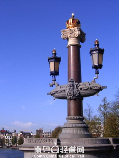
The number of Bridges, large and small, in the canals of Amsterdam needs to be numbered to manage and identify them. The Blue Bridge, numbered 236, is one of the most important landscaped traffic Bridges. The bridge was painted blue in 1883, and the lampposts on the bridge are decorated with heraldry crowns and boat shapes.
Many of the locks were formed at the beginning of the construction of the canal. As modern steel and concrete structures emerged, Amsterdam rebuilt a large number of Bridges to accommodate modern means of transportation and aesthetic values. The Peperbrug, number BRUG 281, was built in 1929 at the center of the city. In 2002, it was included in the Netherlands National Cultural Heritage List. There are 60,000 cultural heritage sites listed at national level in the Netherlands, including more than 1,500 archaeological sites.

The number BRUG283 bridge is a bridge of modern design, 2.85 meters wide and 6.76 meters long. It was listed in the Netherlands National Cultural Heritage List in 2001. The architect was Joan van der Mey (1878-1949), who designed the Shipping House. At the port where the canal enters, the Shipping House, now known as the first truly "Amsterdam School" building in the harbor, remains a historic and tourist monument. It was also the starting point of a Dutch explorer (Cornelis de Houtman, 1596-1599) who set out in 1595 to explore the spices of the East Indies. The Amsden School was an architectural school popular in the early 20th century, similar to the German red brick architecture of the same period. In addition to aesthetic pursuit of the consistency of internal and external structures and traditional Dutch architectural colors, they were also interested in social movements, paying attention to workers' houses, community schools, etc. They completed the first phase of the project from 1913 to 1916. The second phase of the project was completed from 1926 to 1928. It was the headquarters of six shipping companies, including the Dutch Steamship Company, among which the East India Company maintained trade with Asia and maintained trade with Indonesia and Malaysia until the independence of Malaysia. The architect is Gouda-born Joan van der Mey, a member of the Amsterdam Academy in the Netherlands. The interior is in the style of the Art Nouveau movement. The theme of the decoration, such as the exploration in the age of navigation and the exotic atmosphere in the big states of the world, is in line with the business characteristics of the company. It is interesting to note that during the construction of the first phase, the red bricks of the second phase were fired early to ensure the same material and color for the facade of the two phases of the project. In the 1990s, it was listed as one of the Netherlands' 100 Best Historic Sites. Most of the shipping companies moved out in the 1970s, and Amsterdam City Hall Transport became the owner. Since then, the interior has been renovated in the traditional Art Nouveau style and opened in 2007 as a five-star hotel.
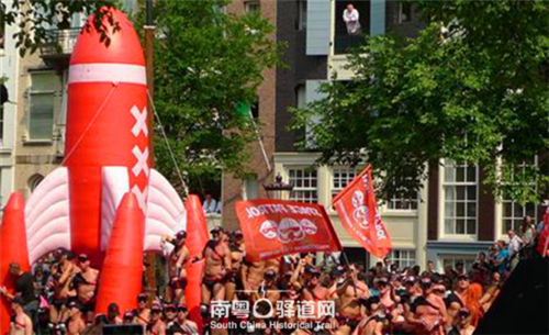
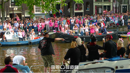
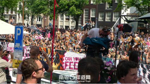
"Amsterdam pride" gay parade in Amsterdam city's most famous few canal, held the first week of August, luxuriant decoration ship carrying the parade of people singing and dancing, some decorations on the boat with marked by three st. Andrew's cross, with the main pattern of city crest elements express the city individuality, It is also the symbol of the organization: the vertical arrangement of the three crosses of St. Andrew and the font of "We are proud", which is the organizational symbol of homosexual Amsterdam, which is enough to show that the visual communication of the city's coat of arms in the city's activities and life is quite extensive. A gay pride parade in Amsterdam, Netherlands, culminates in a canal parade, with colorful boats parading along the canal and the decorations on the boats.
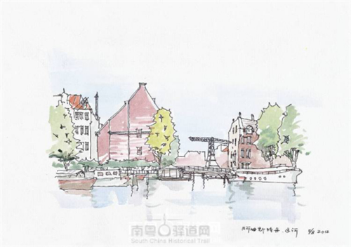
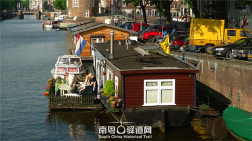
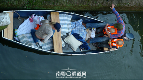
The "Hotel barge" industry was born in the 1960s, when waterway shipping collapsed, with many European shipping companies converting canal-sailing moorings into livable floating hotels. The canal has become a part of the life of the city, and many tourists from other European cities on the singh canal drive their own residential boats to the city's downtown and live along the singh canal.
2.Sunshine Coffee Bar, Canal of Utrecht, Netherlands
The Dutch city of Utrecht was built as a military defensive position during the Roman Empire. In 1122 the city was granted the right to self-government. It was an important religious center in the region between 650 and 1579. It played an important role in the fight against the Habsburg dynasty for Dutch independence, and the urban form was also the basic structure of the reathered defense plus the canal, which is now retained as the city's recreational public space.
Around the canal, due to the convenience of transportation, many public buildings are built on both sides of the canal. For example, the University of Utrecht, built in 1636, is one of the earliest universities in the Dutch Golden Age. The university was founded in the heart of the old city, in the same area as St. Martin's Church. A university building built in 1892 on the street in the downtown area, near the canal. Building entrance, in addition to the typical red turn white outside the framework of typical Dutch architectural style, in tracery wall on the top three floors of the facade decoration with arms as the core, respectively is at the highest level for the sun light of the crest, at the university of the school's motto is "we" justice, sunlight in Latin in the following, is on the second floor of the United Kingdom of the Netherlands sword lion crest, Used from 1816 to 1907, three coats of arms for the province of Utrecht and the city of Utrecht. The shields were guarded by two Greek goddesses.
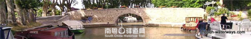
3. Canal du Midi, France
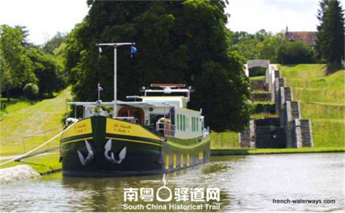
The 2,500-year-old city of Carcassonne, the capital of the French province of Aude, is built around castles built in the Middle Ages, The Cite de Carcassonne, rebuilt in 1853, and the Canal du Midi, which connects Toulouse to the Mediterranean and Atlantic oceans via the Garon, are both listed as World Heritage Sites. The canal has 328 civil works including tunnels, locks, Bridges and so on, which opened the way for the industrial revolution. The unique design makes the canal and the surrounding environment integrated, which is the miracle of civil engineering in the modern history of the world.

The 240-kilometer-long canal was built and designed between 1661 and 1662 by Pierre Paul. Pierre Paul Riquet was supported by the Bishop of Toulouse and King Louis XIV of France. He made profits by collecting taxes. The users used water transportation to reduce transportation costs and changed the geographical conditions of Toulouse, which can be connected to the Mediterranean Sea.
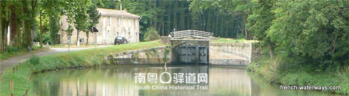
A number of reinforced embankments, navigational lights, and small docks combine aquatic plants with forests on the surrounding banks to create a unique landscape along the way. The agricultural landscape of grapes, sunflowers, and wheat in the area along the route adds to the tourist value of the canal. The Les Onglouss Canal, which opened at the mouth of the sea in 1912, also passes through some of the most beautiful towns in France, including Minervois in Herault and Corbieres in Aude, a famous producer of French wine. There are 65 locks along the canal, with a maximum width of 5.5 meters and a maximum length of 30 meters.
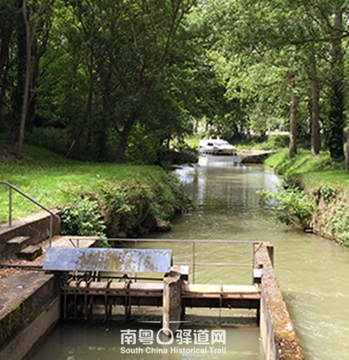
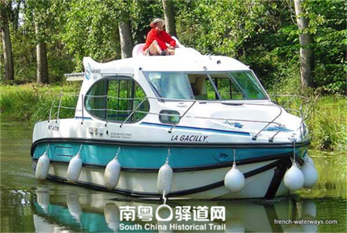
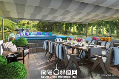
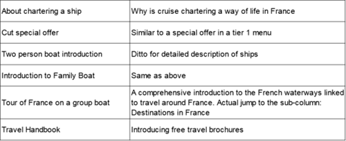
At present, Europe uses similar canals and natural inland rivers to form a network to carry out upstream water, including self-driving tour, houseboat and other options of water travel, quite fashionable. The authoritative website, French-Waterways.com, offers information on the Midi Canal. After research, the editorial department of Nanyu Ancient Road Network believes that this website is defined as a tourism website. Relying on France's rich river tourism resources and its own experience and advantages, it provides comprehensive, practical and professional authoritative information for the majority of tourists and enthusiasts. The following information is provided for the frame diagram of hotel and cruise ship:
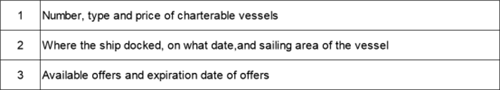
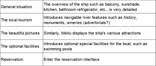
After entering the detailed introduction page, you can learn the details of the ship, including the luxury class of the ship, the decoration style, the comfort level, the route and so on. Under the sub-menu
* About Reservations: This page is accessible to almost all columns on the site. This page provides contact numbers and EMAIL lists for boat service providers so you can contact them anyway.
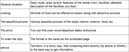
For road cruisers, click "Read More" and you'll be presented with what you want to know about the boat.
Self-drive Boating
Click on the column of Self-Drive Boating to enter the page of Self-Drive Boating. There are 6 sub-columns:
Cruise Tours in France, special offers, destinations in France, boat introductions, luxury boat introductions, orders and contacts. Below talk in detail about the two columns of common problems in France self-driving boat and self-driving boat.
(available by filling in the form)
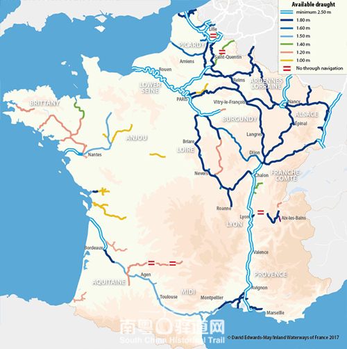
The most important information in the website is the width, height and depth of the channel, and it is worth remembering that the commercial value of navigation in a channel with a draft depth of less than 1.6 metres is lost. European general "boat house" (barges) the standard size is 38.5 meters long, 5.05 meters wide, draft depth 1.8 meters, at the same time there is to adapt to the family, double and self drive a variety of forms of pleasure boat. Each canal has different berthing requirements. For example, the Garonne Canal, which starts from Toulouse and ends at Castete in the Dorte region, was completed in 1856. Today, the largest berthing used in the canal is 5.8 meters wide and 30 meters long. The 193-kilometer-long canal, which is now passable for 38 kilometres, has 53 locks and has been lowered from a maximum elevation of 135 metres to 2 metres.
The industry is now booming. France has the longest man-made canals and natural rivers in Europe, and the sailing and houseboat are managed by the state's governing body, Voies Navigables de France, with an annual revenue of about 60 million euros. Established in 1991, it is the waterway management agency under the jurisdiction of the Ministry of Ecology and Sustainable Development in France, with branches in various parts of the country.
Two hundred years ago, before canal travel became a tourist industry, Thomas Jefferson, the third U.S. president and then French ambassador, visited the Midi Canal and extolled it. Now the French canal leisure tour in Europe is a more developed country, including the safety standards of the berth, the license requirements of the management rules and technical specifications are complete. In addition to the above sites, but also www.elegantways.com, such as professional websites to provide services.
In 2005, when Xi Jinping, then Secretary of Zhejiang Provincial Party Committee, made a survey in Yucun, he pointed out that "clear water and green mountains are golden mountains and silver mountains". Now, the "Two Mountains Learning Base" and the Memorial Park have been set up. From 2003 to 2005, Yucun closed down mines and cement factories to eliminate heavy polluting enterprises and set up the first batch of tourist scenic spots in Anji County. The per capita income of villagers was 7,376 yuan in 2004 and 41,378 yuan in 2017. In Mantang, a village near Yu Cun, there are 400 villagers, three groups of villagers, and 112 households. The main industries are white tea and Huanghua pear. Its original name is "Wantang", which was changed to "Mantang" because of a homonym. At present, green water and green mountains are mentioned more than green mountains, and the actual green water is equally important. In the revitalization and utilization of ancient post roads in southern Guangdong and in the management of water system, the tourism and travel lifestyles in the upper reaches of the water should be planned in advance, so that a happy life is just around us.
(Photos and images of French waterways are sourced from the website French-Waterways.com; other photos and sketches are mine.)
Notes and references:
[1][英]杰弗里.帕克著《城邦——从古希腊到当代》山东画报出版社,2007年,149页
[2]Cornelis Koeman and Marco van Egmond, State Contexts of Renassance Maooing Surveying and official Mapping in Low Countries,1500-1670, The History of Cartography, Volume 3, Part 2,Chapter43 Edited by David
[3][美]斯皮罗-科斯托夫著,单皓译,《城市的形成——历史进程中的城市模式和城市意义》中国建筑工业出版社,2005年,112页
[4]Fred Feddes A Millennium of Amsterdam THOTH Publishers Bussum 2012 p97
[5]Fred Feddes A Millennium of Amsterdam THOTH Publishers Bussum 2012 p81
Responsible editor:He Luoxi